Access streaming data for low-latency client experience regardless of data size.
The MapLarge Platform's ingest capability is designed to connect existing enterprise data stores in a variety of deployment configurations, as well as stream sensor, IoT, and GIS data from external stores. Production MapLarge clusters handle the most demanding workflows including tracking nearly every plane in the sky and every boat in the ocean in near real-time.
Integrate and Process Real-time Multi-source, Multi-phenomenology Data Streams
MapLarge processes real-time sensor data to deliver actionable intelligence for decision support. The platform provides both horizontal and vertical scalability to support hundreds of billions of records with real-time interactivity with ACID compliant reliability and high availability. The MapLarge Platform helps orchestrate multiple sources of data into enterprise applications, running workflows to support day-to-day operations.
a. Terrestrial: Fixed and mobile IoT sensors on land or at sea
b. Airborne: Commercial drone, military/NATO, and baseline commercial imagery
c. Space: Footprint visibility, integrated tasking, and custom payload support
PERFORMANCE

Real Time Streams

Global Scale

Update and Edit Records
LIVE INTERACTIVE DASHBOARDS W/ LIVE DATA

Works with Billions of Records

Blend Multiple Data Sources at Scale
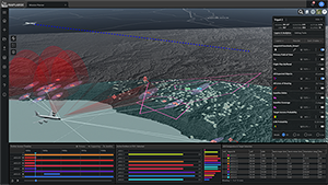
This multi-domain mission planning application supports pre-mission, live ops, and post-mission analysis and execution. During a pre-mission build phase, external sensors and data feeds enrich the operating environment. Low latency (< 1 sec) streaming data updates the 2D/3D map with active objects, including dynamically generating viewshed access on terrain data, updating antenna boresight angles, error ellipses, and coincident access with offboard sensors. In the post-mission phase, a comprehensive replay is available for analysis, reporting production, and mission effectiveness retrospective planning.
PERFORMANCE
Real Time Streams
Global Scale
Update and Edit Records
LIVE INTERACTIVE DASHBOARDS W/ LIVE DATA
Works with Billions of Records
Blend Multiple Data Sources at Scale
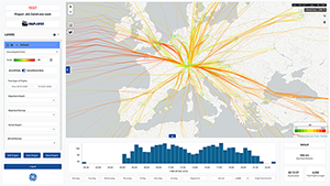
MapLarge’s streaming engine powers aviation solutions for global airline operators. The MapLarge Platform fuses streaming flight track data from global aircraft engines, enabling customers to generate safe and resource optimized ARINC-424 flight procedures.
SCHEMA EVOLUTION CAPABILITY

Graph and Relational Views

Robust Automatic Schemas

Automatic Type Detection

Automated Import UI & API
Automatically Synthesize Multi-source Data Feeds with Robust Connectors, Formats, and Schemas
MapLarge supports a wide array of connection options for streaming data including support for streaming sources like WebSockets, TCP, MQTT, ActiveMQ, RabbitMQ, Kafka, ElasticSearch, and BlobStores (AWS, Azure, and Google). MapLarge supports most common streaming data file formats including XML, JSON, KML, KMZ, CSV, Shapefile, GPX, GeoJSON, and many more.
SCHEMA EVOLUTION CAPABILITY
Graph and Relational Views
Robust Automatic Schemas
Automatic Type Detection
Automated Import UI & API
Explore an Open Ecosystem of Data, Tools, and Services
MapLarge provides an open standards ecosystem, including import, transformations, query, base map visualization, and export that can operate at real-time streaming speed and enterprise scale. Streaming Ingest combined with governance from Security and Sharing & Collaboration building blocks enables an enterprise grade, scalable, standards compliant, and open ecosystem. Examples of systems and standards supported include OGC WMS, WFS, WMTS, KML/Z, CSV, SQL/ODBC/ADO.NET, File GeoDatabase, Google Map, Bing, Open Layers, Leaflet, QGis, MapBox, ArcGIS, S3, Azure Blob, GCS, Kubernetes, Docker, Kafka, MQTT, ActiveMQ, and many others.
STANDARDS SUPPORT

OGC (WFS, WMS, WMTS)

Dozens of Vector formats and thousands of projections

All major raster imagery and FMV (video) formats

DB/SQL connectivity support for most major databases
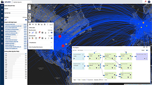
In this use case, the MapLarge platform provides insight into the world's airports, airlines, and connecting flight networks.
STANDARDS SUPPORT
OGC (WFS, WMS, WMTS)
Dozens of Vector formats and thousands of projections
All major raster imagery and FMV (video) formats
DB/SQL connectivity support for most major databases


