Integrate, Service-Enable, and Apply Multi-Model Visual Analytics for Decision Making
The MapLarge Platform prioritizes performant geospatial workflows first, closely followed by other data representations, which provides users with “geospatially native” low latency spatial, temporal, graph, and semantic analytics and visualizations.
Access High Performance at the Platform's Core
MapLarge provides enterprises high performance geospatial infrastructure to develop low-latency applications for enterprise-scale data. High performance geospatial analytics is a principal design consideration and impractical to “bolt on” later in the product life cycle.
GEOSPATIAL QUERIES

Vector

Raster

Hybrid

Geocoding/Reverse Geocoding

Routing

ViewSheds
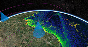
MapLarge's mapping engine renders global maritime track density raster maps (visit globalmaritimetraffic.org) using space and terrestrially collected Automatic Identification System (AIS) signals, including 100B+ historical records plus over 1B new records added monthly.
GEOSPATIAL QUERIES
Vector
Raster
Hybrid
Geocoding/Reverse Geocoding
Routing
ViewSheds
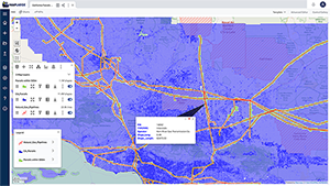
MapLarge provides performant geospatial join operations. In this use case, the MapLarge platform identifies all parcels in the state of California that are within 500 feet of gas pipelines in just seconds. This enables rapid identification and follow-on notification to affected residents ahead of maintenance activities.
COLLECT DATA

Edit Any Record at Scale

Works Offline in the Field with Synchronization
ADVANCED GEO ANALYSIS
Loitering
Pathing/
Routing
Routing
Rendezvous
Track
Analytics
Analytics
Enrich Data with Rapid Join Operations for Geospatial Context
The MapLarge Platform conflates dynamic enterprise GIS data with foundation/infrastructure data like addresses, roads, rivers, geographic boundaries, and other information at any scale. Local context is relevant to delivery and operations across supply chains for timing, selection, resilience, and dynamic routing. Provide publishing solutions that scale to millions of viewers with mission critical high availability.
COLLECT DATA
Edit Any Record at Scale
Works Offline in the Field with Synchronization
ADVANCED GEO ANALYSIS
Loitering
Pathing/
Routing
Routing
Rendezvous
Track
Analytics
Analytics
Enhance Interpretive Analysis with Geospatial, Temporal, Logical, & Semantic Data Representation
The MapLarge multi-model database supports unstructured/semi-structured data warehouse/data lake type capabilities while also supporting real-time online streaming adding queries, distributed locking and rollback constraints, ACID transactions, and other relational database functionality. Multi-model database capabilities include: multi-model queries (geospatial, temporal, & graph), geospatial indexing, full text searches, geocoding and reverse geocoding, network graph, raster imagery and multi-projection coordinate system support.
COORDINATE SYSTEM SUPPORT

Thousands of Projections

Arctic, Antarctic

2D, 2.5D, 3D, 4D

Logical

Extraterrestrial
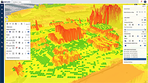
In this use case, LiDAR and SAR data was overlaid on a 3D point cloud mesh to reveal terrain slope to support mission planning, including candidate Helicopter Landing Zone (HLZ) site selection.
COORDINATE SYSTEM SUPPORT
Thousands of Projections
Arctic, Antarctic
2D, 2.5D, 3D, 4D
Logical
Extraterrestrial


