Build embeddable, custom app integrations tailored to your enterprise's unique needs.
MapLarge's open APIs, software development kits (SDKs), and application development kits (ADKs) provide multiple integration channels to extend platform capabilities. These extensions enable custom integrations with existing tools and enable new capability to be developed by leveraging in-house data scientists and software development staff.
Tap Best-in-Class Tools to Integrate with Your Current Software and Data Assets
MapLarge’s low-friction tool integrations support enterprise workflows that use multiple vendor products for user preferences and comparative advantage reasons. This freedom of choice allows enterprises to select “best-in-class” options for their needs while minimizing the risk of being “locked-in” to single vendor environments. MapLarge supports extensive REST JavaScript and TypeScript APIs with SDK support in all major languages including Java, Python, NodeJS, C#, TypeScript, and JavaScript.
ADK / EXTENSION FRAMEWORK

Documentation

API Integration

Developer Customizations

Developer Experience / Knowledge

MapLarge’s extensibility building block allows development of new features requiring client and server-side integration. In this instance, MapLarge integrated sensor readings from instrumented well-logging probes collected over time and over a relatively wide geographical area. MapLarge employed a kriging method to interpolate sensor readings between the pilot hole recordings to generate a subsurface topographic map to aid in hydrocarbon exploration.
ADK / EXTENSION FRAMEWORK
Documentation
API Integration
Developer Customizations
Developer Experience / Knowledge
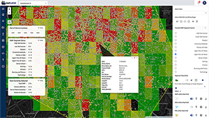
The MapLarge Platform integrates with and extends enterprise data, visualizations, and applications. In this application, anonymized cell phone data is used to analyze demographic-rich patterns of life to deliver targeted digital advertising to select viewers via the optimal channel, time, and place.
EFFICIENT MANAGEMENT

Community Support/Adoption

Management Service

Ease of Maintenance

Configurable
Efficiently Bring New Capabilities to Enterprise Programs
The MapLarge Platform has integration points for client-side, server-side, and custom application development. This allows application extension development using an Application Development Kit (ADK), supporting server-side analytics as well as advanced analytic dashboards and workflows developed in C#, Python, Java, R, Javascript, or Typescript.
EFFICIENT MANAGEMENT
Community Support/Adoption
Management Service
Ease of Maintenance
Configurable
Employ Your Broader Workforce with Multiple Skill-Level Integration Points
MapLarge facilitates enterprise stakeholder adoption with no-code, low code, and full stack integration points tailored to stakeholders of different skill levels. Development efforts are supported by SDK, API, and documentation that reduce friction for developers, data scientists, and business analysts.
STANDARDS SUPPORT

OGC (WFS, WMS, WMTS)

Dozens of Vector formats and thousands of projections

All major raster imagery and FMV (video) formats

DB/SQL connectivity support for most major databases
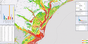
MapLarge provides real-time situational awareness to enterprise operation centers to protect field personnel in harm's way. The extensible framework allows multiple vendor risk intelligence data products and services to be efficiently integrated with GIS mapping. In this application, topography, infrastructure, and dynamic weather data updates a flood risk model, providing alerts to at-risk field personnel on GPS-enabled mobile devices.
STANDARDS SUPPORT
OGC (WFS, WMS, WMTS)
Dozens of Vector formats and thousands of projections
All major raster imagery and FMV (video) formats
DB/SQL connectivity support for most major databases


