Move from Data to Decisions in Minutes with MapLarge's Drag-and-Drop Analytics and Automation APIs
MapLarge provides a library of analytic functions powered by MapLarge's multi-model database that integrates relational, graph, geospatial, key value pair, document model, object store, and raster store representations from enterprise data lakes. In addition, the platform integrates custom, open source, commercial and/or government off-the-shelf analytics in GIS workflows.
Fast-Track Your Analysis Efforts with Out of the Box Analytics and Workflows
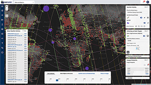
Enterprise operations require high-performance multi-source analytics both out of the box and with the flexibility to independently integrate or develop multi-source analytic capabilities. Users may dynamically query the data, explore logical relationships with graph query support, and establish centralized tooling from disparate data sources for a wide variety of operational use cases.
Space-Time Cube Aggregate
Spatial Grid Aggregate
Compare & Contrast Grid
``
Find Dwell Acivity
Objects to Tracks
Tracks to Objects
Find Origin and Destination
Find Intersectinon Events
Create Track Segments
Find Tracks Along Paths
Calculate Distribution Statistics
Generate Blank Grid
Point to Line
Point to Poly
Compare Two Column Values
Object Co-Dwell
Find Dwells Near/ Far From Objects
Compare Time Periods
Normalcy
Rolling Baseline Comparison
Object Association Graph
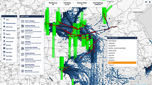
MapLarge's Out of the Box Analytic Toolkit supports analytics in multiple domains ranging from land, sea, air, space, indoor, and logical graphs. Capabilities include advanced GIS and track analytics using dynamic sensor data such as GPS, AIS, ADS-B, Imagery, FMV, SAR, LiDAR and more.
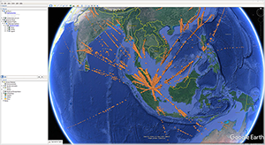
MapLarge integrates with a variety of analytic tools common in the Public and Private sectors. In this example, MapLarge extends Google Earth's capability with a bi-directional integration allowing Google Earth to view, style, and interactively filter billions of records, which exceeds its native capabilities. MapLarge also supports many other mapping API integrations like Google Maps, Bing Maps, MapBox, ArcGIS, Cesium, QGIS, ATAK, and any OGC compatible client.
COLLECT DATA

Edit Any Record at Scale

Works Offline with Synchronization
ADVANCED GEO ANALYSIS
Loitering
Pathing/
Routing
Routing
Rendezvous
Track
Analytics
Analytics
Enhance Your Tool Set, Including Open Source, Commercial, & Government Off The Shelf
A Bring-Your-Own paradigm enables MapLarge users to integrate data, analytics, and visualizations of their choosing in a workflow to encapsulate tradecraft and improve performance limitations of 3rd party tools. Enterprises may employ the MapLarge Platform as an ephemeral fast client for rapid visualization of ad hoc federated queries. MapLarge provides bidirectional integrations with all major clouds including Azure, AWS, Google Cloud, OpenShift, Kubernetes and Docker. Application level integrations include support for ArcGIS Pro, Google Earth, Tableau, PowerBI, Qlik, Analyst Notebook, JEMA, ATAK and more.
COLLECT DATA
Edit Any Record at Scale
Works Offline with Synchronization
ADVANCED GEO ANALYSIS
Loitering
Pathing/
Routing
Routing
Rendezvous
Track
Analytics
Analytics